New and Improved Features in ArcGIS 10.1

ArcGIS 10.1 scheduled to be released early in 2012, while the Beta 1 version will be released this July. ESRI ArcGIS will use Beta Community http://betacommunity.esri.com to introduce ArcGIS 10.1 beta is. For users of the U.S. can register on the site, while users from other countries must be nominated by the country concerned ESRI distributor. What are the new and improved features in ArcGIS Desktop 1.10?


Here are the Top 10 Improvement in 10.1 For ArcGIS Desktop:

10. The increase in the search menu / Searching, searching with ease transform and determination of the proper projection systems, spatial filtering to search in the map being displayed and to support spatial search for a specific keyword.

9. Update your information in the menu editor tracking Editor

8. Geotag photos auto generate feature points of the folder containing the photos that have been geotagged.

7. GPX to features tool features are now available by default to display GPS data waypoints, tracks and routes. In ArcGIS 10 I use this add-in toolbox Convert GPSFile to SHP

6. KML to Layers feature supports the use of pop-ups import simboldan

5. Two new features in Cartography generalization tools to make the area a way to ease simplification scale changes that were previously only dilakuakan manually.

4. The new interface for administration geodatabase that the user can perform view and locking arrangements geodatabase.

3. Improvements to Labeling feature with automatic placement deksripstif text on the map.

2. Legend dynamic that could change with the change of map scale.

1. Share As new features for ease of sharing spatial data and map-making package (package map).

ESRI has also announced changes in ArcGIS 10.1 naming because the fact is, however ArcGIS is used, basically using the same system.

Showing Results Thumb Picture Geotagging in ArcMap I try to make special tips on how to view picture thumb ArcMap fromthe geotagged photo using free geotagging software GPicSync.About GPicSync I've ever posted here before, namely applicationsthat function automatically inserts location information to the photometadata (geotagging) so the photo can be displayed in Google Earth (KML format) using the reference GPS track timeline.


GPicSync each photo for the geotagging process always generateKML files that can be opened in Google Earth or ArcGIS ExplorerDesktop. In addition, also automatically generate a folder with the name Thumbs containing the photo but with small dimensions(resize the result) that is 160x120 pixels. By utilizing the KML file(usually has a name doc.kml) and the Thumbs folder you cancreate picture thumb in ArcMap using the Add-in toolbox ConvertGPSFile to SHP through sub-tools KML to SHP. About Add-intoolbox Convert GPSFile to SHP I've ever posted here.

Download Map High Resolution 2011 Forest Moratorium

Government through the Ministry of Forestry has issued a newpermit delays indicative map (map forest moratorium) ofPresidential Instruction 10/2011 on the new license suspension and completion of primary governance of natural forests and peatlands.You can download a moratorium on forest maps with high resolutionjpg format with a scale of 1:250.000 through Forestry WebGIS site.


Map of forest moratorium, according to the Secretary General of the Ministry of Forestry, made ​​using radar images and will be updatedevery six months sekali.Anda can download maps with a scale1:250.000 forest moratorium (291 Sheets) in JPEG format via thelink below


Dowload Peta Moratorium Hutan 2011


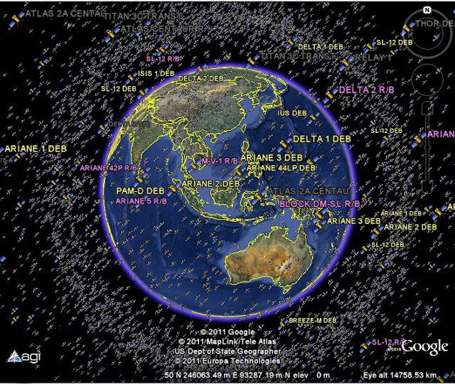
Seeing the Real Time Satellite Position All Around the Earth Through Google Earth Here is the real time position (updates after 30 seconds) approximately 13.000 satellites around the planet That you can seein Google Earth. This collection was developed by someone namedMatt from Analytic Graphics Inc. ..


The picture looks like the above, or you can see the position of thesatellite in real time updates every 30 seconds from the Googlegadget below (takes 30-60 seconds to be able to show satellitepositions, depending on the speed of your computer).

You can also download satellite position kmz file (46 kb) to be opened in Google Earth, or simply view it through a YouTube videoat this link.
Satellite Around The Earth

Gadgets powered by Google

GIS Image Using Open Source GIS uDIG


GIS image using one of the Open Source GIS which is an alternative uDIG selaingeoreference using GIS and Quantum GISimage also conducted using ArcGIS Explorer (free download of thelatest ESRI GIS Viewer is here). Previously also shown how to use the Global Mapper GIS contained in the e-book "Making GIS ImageResults Download from Google Maps", sertarektifikasi image / image using ArcGIS Desktop here.

GIS image using this uDIG utilizing the latest plugin ImageGeoreferencing View, version 1.0.0. This plugin is already inujicobakan using uDig 1.2.1. Video below present the use of the plugin where the user adds the path as a base layer ground controlpoints (GCP).

Garmin Nuvi 3770LM release with 3D Building Indonesia Indonesia Garmin GPS navigator released a new variants, namelyNuvi 3770LM (LM: Live Map Update Time) with a special feature isthe 3D view 3D terrain building and to several cities in Indonesia.You can see a representation of high buildings in various cities andcontour maps at low zoom levels, which gives a realistic perspective on terrain.

Besides GPS Garmin Nuvi 3770LM player also features audio / video and portable media, compass, comes a new capacitivemultisentuh screen designed using clear glass, clear, and more sensitive, technological nĂ¼Route ™ with myTrends ™, navigation isactivated by voice, info line with the look of a crossroads, as well asmap updates free for life.

Spatial Analysis Determining the Place of Hiding Osama bin Laden Professor of Geography University of California-Los Angeles (UCLA) Thomas Gillespie and John Agnew, using spatial analysisto determine the hiding place of Osama bin Laden. They makemodels of the terrorist leader's quest to use the same technique totrack the animals and migratory patterns.


Credit: MIT International Review
A number of biological models can be very useful in finding Osamabin Laden.Pertama called the theory of distance decay (DD). This theory describes the effect on the cultural distance or spatialinteractions. The possibility of finding other animals decreasedexponentially when going further from the residence.

Both called the Island Biogeography (IB), this theory refers to thearea of ​​habitat surrounded by a region uninhabitable.

Through both ways, information about a particular animal will be narrowed on the animals could be found. Through DD, bin Laden is known will not go far from the last place he had known. Through theIB, bin Laden is known to be most likely to be found in big cities.